7 Days Kilimanjaro Climbing – Lemosho Route : The Lemosho path is one of Mount Kilimanjaro’s newer routes. Lemosho’s path begins in the west and, unlike Machame, crosses the Shira Plateau from Shira Ridge to Shira Camp. Climbers experience little traffic until they reach the Machame path. After there, Lemosho takes the same route through Lava Tower, Barranco, and Barafu, known as the Southern Circle. The minimum number of days required for this journey is six, while seven or eight days are preferable. Lemosho is regarded as the most picturesque route on Kilimanjaro, offering panoramic views from several sides of the mountain. It is our favorite route because it strikes a good balance between minimal traffic, stunning views, and a high summit success rate. Thus, Lemosho is highly recommended.
THE 7-DAY LEMOSHO ROUTE ITINERARY
DAY 00: ARRIVAL
Upon your arrival at the Tanzania airport, you shall be picked up and transferred to your lodge of stay in Moshi town. Check in and relax as you wait for dinner and an overnight stay, getting ready to start your Lemosho route trek the next morning.
DAY 1: LONDOROSSI GATE TO MTI MKUBWA
After breakfast at the lodge, you will be picked up by our driver guide and driven to Londorossi Gate, where you will complete entry procedures. We then head to the Lemosho trailhead. When we get to the trailhead, we continue our journey through pristine woodland to the first campsite.
- Lemosho Glades to Mti Mkubwa (Big Tree) Camp
- Elevation (ft): 6,825ft to 9,100ft
- Distance: 7 km
- Hiking Time:3-4 hours
- Habitat: Rain Forest
DAY 02: MTI MKUBWA TO SHIRA 2 CAMP
We continue along the trail, which leads out of the jungle and into a savannah of tall grasses, heather, and volcanic rocks adorned with lichen barbs. After climbing through the lush slopes and across multiple streams, we arrive at Shira Ridge and slowly drop to Shira Camp 1. We get our first look at Kibo on the other side of the plateau.
- Altitude: 9,498 to 11,500 feet.
- Distance: 8 km/5 miles
- Hiking time: 5–6 hours
- Habitat: Health
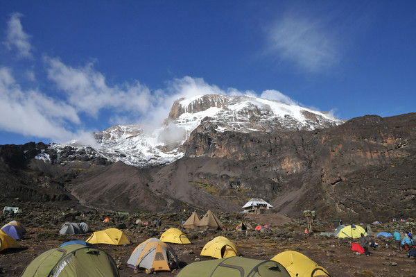
DAY 03: SHIRA CAMP 2 TO BARRANCO CAMP
From the Shira Plateau, we continue east along a ridge, reaching the Kibo Peak intersection. Continuing, we turn southeast toward the lava tower known as “Shark’s Tooth” (height 4650 m/15,250 ft). Shortly after the tower, we reach the second junction, which leads to the Arrow Glacier. We now head down to Barranco Camp. Although you conclude the day at almost the same altitude as when you started, this day is critical for acclimatization and will help your body prepare for summit day.
- Altitude: 3850 m/12,600 ft to 4000 m/13,000 ft
- Distance: 8km/5mi
- Walking time: 5–6 hours
- Habitat: Semi-desert
- Meals: breakfast, lunch, and dinner
DAY 04: BARRANCO CAMP TO KARANGA CAMP
After breakfast, we leave Barranco and follow a hard ridge up the Barranco Wall to the Karanga Valley and the intersection with the Mweka Trail.
- Elevation: 4000 m/13,000 ft to 4050 m/13,250 ft
- Distance to climb: 5 km/3 mi
- Climbing time: 3–4 hours
- Habitat: Alpine desert
- Meals: breakfast, lunch, and dinner
DAY 5: KARANGA CAMP TO BARAFU CAMP
We continued to Barafu Camp. You’ve finished the southern circuit, which provides views of the top from several positions. We set up camp, rest, have dinner, and prepared for summit day.
- Elevation: 4050 m/13,250 ft to 4700 m/15,350 ft
- Distance to go: 4 km/2 mi
- Climbing time: 3–4 hours
- Habitat: Alpine desert
- Meals: breakfast, lunch, and dinner
DAY 06: BARAFU CAMP TO MWEKA CAMP
We continue our journey to the peak between the Rebmann and Ratzel glaciers in the early hours (midnight to 2 a.m.). You go northwest and ascend over dense scree to Stella Point on the crater rim. This is the most psychologically and physically demanding portion of the journey. At Stella Point, you can take a quick break and be rewarded with the most spectacular sunrise you’ve ever witnessed. Faster hikers can view the sunrise from the peak.
Snow may be encountered during the hour-long ascent to the summit from Stella Point. Uhuru Peak is the highest point on Mount Kilimanjaro and the African continent!
We begin our descent from the mountain by heading straight down to Mweka Camp, with a lunch stop at Barafu. You might wish to wear gaiters and trekking poles for the loose gravel on the way down. We arrive at Mweka Camp and spend our final evening on the mountain.
- Elevation: 4700 m/15,350 ft to 5895 m/19,340 ft
- Descent to 3090 m/10,150 ft
- Distance: 5 km/3 mi up, 13 km/8 mi down
- Hiking time: 5-7 hours up, 5-6 hours down
- Habitat: Rocky scree and an ice-covered summit
- Meals: breakfast, lunch, and dinner
DAY 7: MWEKA CAMP TO MWEKA GATE TO ARUSHA.
After breakfast, we’ll head downhill to the Mweka Park Gate to get your summit certificates. At lower elevations, it may be damp and muddy. Gaiters and trekking poles will be helpful. Shorts and t-shirts will generally be sufficient (have rain gear and warmer garments on hand). Meet your guide at the gate for a transfer to Arusha or the airport, which will bring your trip to a close.
- Elevation: 3090 m/10,150 ft to 1680 m/5500 ft
- Distance: 10km/6mi
- Hiking time: 3-4 hours
- Habitat: Forest
- Meals: Breakfast
PRICE INCLUDES:
- Camping fees
- Salary for crew (guide, porters, and cook)
- Rescuer fees
- Three meals per day (breakfast, lunch, dinner, and mineral water)
- Tent, foam, cooking equipment, and eating utensils
- Oxygen Cylinder and Oxymeter
- All government taxes (VAT)
NOT INCLUDED:
- Tips for crews (guide, porters, and cook)
- Some equipment is available for rent.
- Extra personal needs (cigarettes and alcohol drinks)
